Discovery
The Discovery process of FEMA’s Risk Mapping, Assessment and Planning (Risk MAP) program helps communities identify areas at risk for flooding and solutions for reducing that risk by working directly with the communities in the watershed to gather information about local flood risks.
The Goal
- To work closely with communities;
- To better understand local flood risk, mitigation efforts, and other topics; and
- To spark watershed-wide discussions about increasing resilience to flooding.
Discovery Activities
- Gather information about local flood risk and flood hazards
- Review mitigation plans to understand local mitigation capabilities, hazard risk assessments, and current or future mitigation activities
- Support communities within the watershed to develop a vision for the watershed’s future
- Collect information from communities about their flooding history, development plans, daily operations, and stormwater and floodplain management activities
- Use all information gathered to determine which areas of the watershed require mapping, risk assessment, or mitigation planning assistance through a Risk MAP project
Located in North Texas, the Upper West Fork Watershed is part of the Trinity River Basin. It has been identified by the federal government using a national standard hierarchical system which is based on surface hydrologic features. The Upper West Fork is classified as a fourth-level (sub-basin) with a unique 8-digit Hydrologic Unit Code (HUC) - #12030101.
The Upper West Fork watershed crosses eight counties. These counties include: Tarrant, Parker, Wise, Jack, Montague, Clay, Archer, and Young. The watershed either totally covers or partially spans 20 cities/towns in the NCTCOG region.
Ash Creek, Walnut Creek, Big Sandy Creek, and the West Fork of the Trinity River are among the primary creeks and rivers in the watershed. The West Fork of the Trinity River flows into Eagle Mountain Lake reservoir in Tarrant County, and ultimately to the Trinity River. Each of the four branches (the West Fork, Clear Fork, Elm Fork and East Fork) of the Trinity begins its journey near the Texas-Oklahoma border near the Red River. The Trinity River completes its journey at Trinity Bay (the northeast portion of Galveston Bay) in Chambers County.
Upper West Fork Discovery Website:
https://nctcogdiscovery.halff.com
Password: NCTCOG_2022!
View Upper West Fork Trinity Discovery Findings Report Draft
View Upper West Fork Trinity Discovery Findings Report Appendices
View Upper West Fork Trinity Discovery Findings Presentation
9/27 Upper West Fork Trinity Discovery Findings Meeting
For pre-discovery presentation, click here.
View the Upper West Fork Watershed Pre-Discovery Newsletter
9/27 Upper West Fork Trinity Pre-Discovery Meeting
9/29 Upper West Fork Trinity Pre-Discovery Meeting
Located in North Texas, the Richland and Chambers watersheds are part of the Trinity River Basin. The watersheds have been identified by the federal government using a national standard hierarchical system which is based on surface hydrologic features. The Richland Watershed is classified as a fourth-level (sub-basin) with a unique 8-digit Hydrologic Unit Code (HUC) - #12030108. The Chambers Watershed is classified as a fourth-level (sub-basin) with a unique 8-digit Hydrologic Unit Code (HUC) - #12030109.
The Richland and Chambers watersheds cover an area of nearly 2000 square miles and cross into six (6) counties. These counties include: Ellis, Freestone, Hill, Johnson, Limestone, and Navarro. The watersheds either totally cover or partially span sixty-nine (69) cities/towns.
Chambers and Mill Creeks are the primary rivers in the watershed, which flow into the Richland-Chambers Reservoir in southeast Navarro County, and ultimately to the Trinity River. Each of the four branches (the West Fork, the Clear Fork, the Elm Fork, and the East Fork) of the Trinity begins its journey near the Texas-Oklahoma border near the Red River. The Trinity River completes its journey at Trinity Bay (the northeast portion of Galveston Bay) in Chambers County.
The Richland-Chambers Discovery Project was completed by Halff Associates in conjunction with NCTCOG in 2020.
Located in North Texas, the East Fork Trinity Watershed is part of the Trinity River Basin. It has been identified by the federal government using a national standard hierarchical system which is based on surface hydrologic features. The East Fork Trinity Watershed is classified as a fourth-level (sub-basin) with a unique 8-digit Hydrologic Unit Code (HUC) - #12030106.
The East Fork Trinity Watershed covers an area of 1328 square miles and crosses into seven (7) counties. These counties include: Collin, Dallas, Fannin, Grayson, Hunt, Kaufman, and Rockwall. The watershed either totally covers or partially spans across forty-three (43) cities and towns.
The East Fork Trinity is the primary river in the watershed, which flows into the Trinity River at the Kaufman-Ellis county line. Each of the four branches (the West Fork, the Clear Fork, the Elm Fork, and the East Fork) of the Trinity begins its journey near the Texas-Oklahoma border near the Red River. The Trinity River completes its journey at Trinity Bay (the northeast portion of Galveston Bay) in Chambers County.
The East Fork Discovery Project was completed by Halff Associates in conjunction with NCTCOG in 2019.
Located in North Texas, the Cedar Watershed is part of the Trinity River Basin. It has been identified by the federal government using a national standard hierarchical system which is based on surface hydrologic features. The Cedar Watershed is classified as a fourth-level (sub-basin) with a unique 8-digit Hydrologic Unit Code (HUC) - #12030107.
The Cedar Watershed covers an area of 1303 square miles and crosses into five (5) counties. These counties include: Henderson, Kaufman, Navarro, Rockwall, and Van Zandt. The watershed either totally covers or partially spans across twenty-eight (28) cities and towns.
Cedar Creek is the primary river in the watershed, and flows into the main stem of the Trinity River below Cedar Creek Reservoir. Each of the four branches of the Trinity (the West Fork, the Clear Fork, the Elm Fork, and the East Fork) of the Trinity begins its journey near the Texas-Oklahoma border near the Red River. The Trinity River completes its journey at Trinity Bay (the northeast portion of Galveston Bay) in Chambers County.
The Cedar Discovery project was completed in 2017 by Halff Associates in conjunction with NCTCOG. The draft Discovery Findings Report can be viewed below.
Located in North Texas, the Denton Watershed is part of the Trinity River Basin. It has been identified by the federal government using a national standard hierarchical system which is based on surface hydrologic features. The Denton Watershed is classified as a fourth-level (sub-basin) with a unique 8-digit Hydrologic Unit Code (HUC) - #12030104.
The Denton Watershed covers an area of 719 square miles and crosses into six (6) counties. These counties include: Cooke, Dallas, Denton, Montague, Wise and Tarrant. The watershed either totally covers or partially spans across twenty-four (24) cities and towns.
Denton Creek is the primary river in the watershed, which flows into the Elm Fork Trinity below Grapevine Lake. Each of the four branches (the West Fork, the Clear Fork, the Elm Fork, and the East Fork) of the Trinity begins its journey near the Texas-Oklahoma border near the Red River. The Trinity River completes its journey at Trinity Bay (the northeast portion of Galveston Bay) in Chambers County.
The Denton Discovery project was completed in 2017 by Halff Associates in conjunction with NCTCOG. The draft Discovery Findings Report can be viewed below.
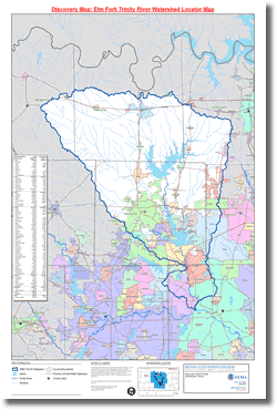
Risk MAP Discovery - Elm Fork Trinity Watershed
Located in North Texas, the Elm Fork Trinity Watershed is part of the Trinity River Basin. It has been identified by the federal government using a national standard hierarchical system which is based on surface hydrologic features. The Elm Fork is classified as a fourth-level (sub-basin) with a unique 8-digit Hydrologic Unit Code (HUC) - #12030103.
The Elm Fork Watershed covers an area of 1857.7 square miles and crosses into eight (8) counties. These counties include: Collin, Cooke, Dallas, Denton, Grayson, Montague, Tarrant, and Wise. The watershed either totally covers or partially spans across fifty-two (52) cities/towns. The Elm Fork contains about 5% of the State's total population with approximately 1,218,000 residents.
The Elm Fork of the Trinity River is the primary river in the watershed. Each of the four branches (the West Fork, the Clear Fork, the Elm Fork, and the East Fork) of the Trinity begins its journey near the Texas-Oklahoma border near the Red River. The Trinity River completes its journey at Trinity Bay (the northeast portion of Galveston Bay) in Chambers County.
The Elm Fork Discovery Project was completed in 2013, and the final report can be viewed below.
 Elm Fork Trinity Watershed Related Information
- Elm Fork Discovery Findings Report (PDF, 87 MB)
- Locator Map
- Cities and towns affected by watershed
- Elm Fork Discovery Newsletter
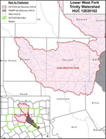 Risk MAP Discovery - Lower West Fork Trinity Watershed
Located in North Texas, the Lower West Fork Trinity Watershed is part of the Trinity River Basin. It has been identified by the federal government using a national standard hierarchical system which is based on surface hydrologic features. The Lower West Fork is classified as a fourth-level (sub-basin) with a unique 8-digit Hydrologic Unit Code (HUC) - #12030102.
The Lower West Fork Watershed covers an area of 1513.7 square miles and crosses into seven (7) counties. These counties include: Dallas, Ellis, Hood, Johnson, Parker, Tarrant, and Wise. The watershed either totally covers or partially spans across fifty-five (55) cities/towns. The Lower West Fork contains about 9% of the State's total population with approximately 2,378,000 residents.
The West Fork of the Trinity River is the primary river in the watershed. Each of the four branches (the West Fork, the Clear Fork, the Elm Fork, and the East Fork) of the Trinity begins its journey near the Texas-Oklahoma border near the Red River. The Trinity River completes its journey at Trinity Bay (the northeast portion of Galveston Bay) in Chambers County.
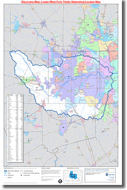 The Lower West Fork Discovery Project was completed in 2013, and the final report can be viewed below.
Lower West Fork Trinity Watershed Related Information
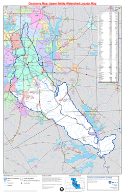
Risk MAP Discovery - Upper Trinity Watershed
Located in North Texas, the Upper Trinity Watershed is part of the Trinity River Basin. It has been identified by the federal government using a national standard hierarchical system which is based on surface hydrologic features. The Elm Fork is classified as a fourth-level (sub-basin) with a unique 8-digit Hydrologic Unit Code (HUC) - #12030105.
The Upper Trinity Watershed covers an area of 1369.52 square miles and crosses into nine (9) counties. These counties include: Anderson, Collin, Dallas, Ellis, Freestone, Henderson, Kaufman, and Navarro. The watershed either totally covers or partially spans across forty-six (46) cities/towns.
The Trinity River is the primary river in the watershed. Each of the four branches (the West Fork, the Clear Fork, the Elm Fork, and the East Fork) of the Trinity begins its journey near the Texas-Oklahoma border near the Red River. The Trinity River completes its journey at Trinity Bay (the northeast portion of Galveston Bay) in Chambers County.
The Upper Trinity Discovery project was completed in 2013 by FEMA’s RAMPP team in conjunction with NCTCOG. The final report can be viewed below.
 Upper Trinity Watershed Related Information
- Upper Trinity Discovery Findings Report (PDF, 14 MB)
- Locator Map
- Cities/Towns affected by watershed
- Upper Trinity Pre-Discovery Newsletter
Additional Resources
- FEMA Region 6
- USACE Fort Worth District
- Texas Water Development Board
- Texas Natural Resources Information Systems (TNRIS)
- TCEQ Dam Safety Program
For more information, please contact NCTCOG Staff at 817-695-9210 or EandD@nctcog.org.