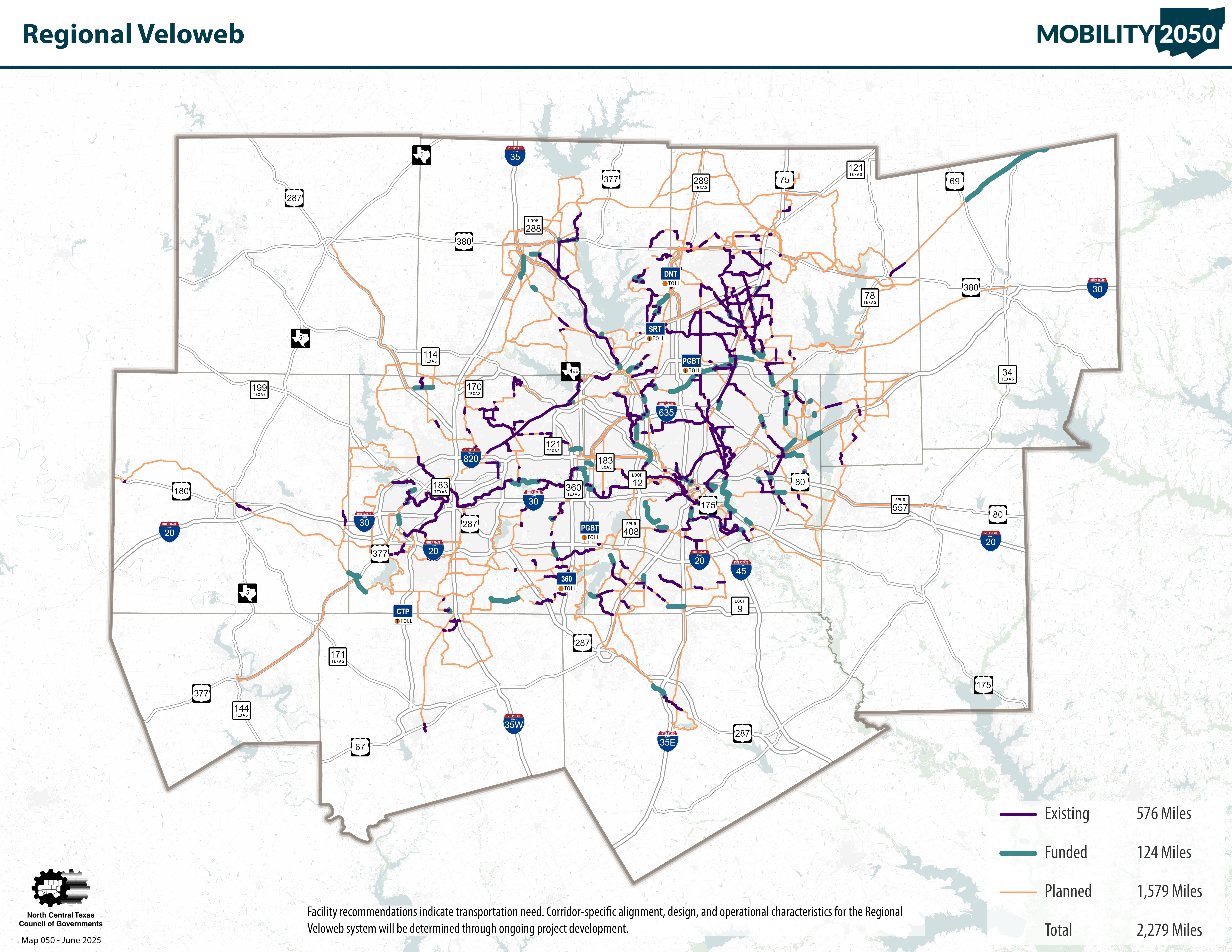
2050 Regional Veloweb
The Regional Veloweb is a network of over 2,200 miles of off-street shared-use paths (trails) designed for multi-use trip purposes by bicyclists, pedestrians, and other non-motorized forms of transportation adopted as part of Mobility 2050. The Regional Veloweb serves as the regional expressway network for active transportation, and it extends the reach of the region’s roadway and passenger rail transit network for non-motorized transportation. The Regional Veloweb has planned connections in 12 counties and 119 cities in North Central Texas. Community Pathways are similar to the Regional Veloweb; although they may not provide a connection to a major destination, they help supplement the regional network. Alignments were determined through the cooperative efforts of local governments and NCTCOG staff by:
- Identifying existing and funded facilities.
- Reviewing locally planned bicycle and pedestrian facilities.
- Locating routes that would provide air quality benefits and access to transit stations and major destinations.
- Identifying corridors that provide the greatest potential for regional connectivity.
The Regional Veloweb is adopted by the Regional Transportation Council, the transportation policy body of the Metropolitan Planning Organization, as part of the long-term metropolitan transportation plan for the Dallas-Fort Worth area. Corridors identified on the Regional Veloweb as “planned” may be prioritized for future funding. Cities and counties within the region are responsible for the planning and implementation of bicycle and pedestrian infrastructure and amenities. The North Central Texas Council of Governments (NCTCOG) takes those plans and promotes connections throughout the region, with a focus on alternative commute routes.
These shared-use paths are expected to be consistent with the recommendations and design guidance set forth by the American Association of State Highway Officials (AASHTO) for the development of bicycle facilities. Facilities that are federally funded are required to comply with AASHTO guidance. Design considerations for regional and community pathways are described in more detail in the table below.
For a snapshot of regionally significant trail systems, view our 2024-2025 Regional Trails Brochure and Map.

Regional Pathways 2050 Primary Design Considerations |
Consistent with the guidance set forth by AASHTO for the development of bicycle facilities. |
Minimum width: 12 to 14 feet (typical) with 16- to 24-foot-wide sections or separated facilities for pedestrians and bicyclists in areas with high-peak user volumes. |
Typically, independent right-of-way corridors such as greenways, along waterways, freeways, active or abandoned rail lines, utility rights-of-way, and unused rights-of-way. |
Continuous linear corridors can help provide long-distance connections through cities and across counties; provide connections to major destinations, or recuring events including transit stations, employment and education centers, and/or other major activity venues with high volumes of users. |
Grade-separated crossing of roadways with significant traffic flows. Few, if any, driveway crossings and signalized or stop sign intersections. |
Supported by a network of local community paths, sidewalks, and on-street bikeways that provide connections to local neighborhood destinations. |
Constructed with a long-lasting impervious surface. |
Community Pathways Primary Design Considerations |
Consistent with the guidance set forth by AASHTO for the development of bicycle facilities. |
Minimum width: 10 to 14 feet (typical) with wider sections where appropriate or when warranted due to observed or anticipated high-peak volumes. |
May include more alignments adjacent to local collector and arterial roadways, and through neighborhoods and areas where right-of-way is more constrained and user volumes are lower. |
Corridors generally shorter in length and may terminate within a community; may supplement adjacent on-street bikeways along roadways with higher traffic speeds and volumes not suitable for less experienced bicyclists and may provide short connections between on-street bikeways and neighborhoods. |
May include more at-grade crossings of roadways with signalized or stop sign intersections while minimizing any conflicts with motor vehicles and associated operational and safety issues. |
Serves as an extension of the regional pathway network by providing connections to local neighborhood destinations. |
Constructed with a long-lasting impervious surface. |
Click on a link below to return to the Trails and On-Street Bikeways Network home page, view expanded maps and read more about community paths and on-street bikeways.
